By JAN McLAUGHLIN
BG Independent News
After learning earlier this year that half of Bowling Green parents feel it’s unsafe to let their children walk or ride bikes to school, city officials applied for Safe Routes to School funding from the state.
On Tuesday, Gov. Mike DeWine announced that the City of Bowling Green had been selected to get $500,000 from the state to help alleviate some of those safety concerns.
The funding will be put toward a multi-use path stretching from Crim Elementary School to Carter Park – connecting all the neighborhoods in between with the school and the park.
“This will at least get us started,” City Communications Director Amanda Gamby said, noting that the entire length of the multi-use path is estimated to cost $1.6 million.
“We’re thrilled to get the maximum amount,” of $500,000 Safe Routes to School funding, Gamby said.
The state funding, along with $225,000 in American Rescue Plan Act funds earmarked for the pathway by the city, will help with the portion from Crim Elementary to South Mercer Road. The city is currently searching for other sources of funding to help with the portion between South Mercer Road and Carter Park.
“We’re looking for other funding opportunities,” Gamby said.
The asphalt multi-use path will be 11 feet wide, and will require multiple crosswalks as the path crosses roadways. Construction of the path is predicted for 2028.
The city’s request for Safe Routes to School money came after a community meeting held earlier this year. Parents and other community members expressed concerns about letting children walk or ride bikes to their schools.
“The community should be proud of their work on this,” Gamby said.
Bowling Green Superintendent Ted Haselman applauded the efforts to improve safety for children.
“Anytime we can provide a way to make schools more accessible, that’s a good thing,” Haselman said. “This will help provide safer access.”
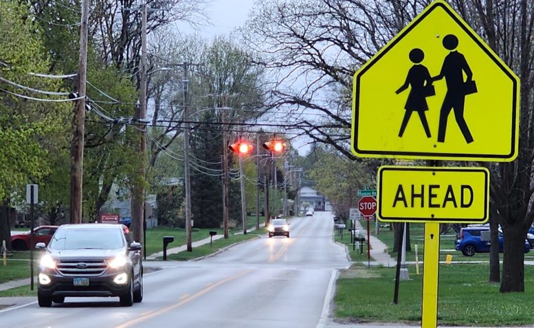
As part of the city’s overall plan, the second project to be submitted for state funding will be pedestrian hybrid beacons at two crosswalks, one at East Wooster and Enterprise streets, and one on West Poe Road near Darlyn Avenue, in front of the high school.
The city already has plans to place a pedestrian hybrid beacon at the intersection of West Wooster Street and Maple Street. That project is expected to cost about $200,000.
These projects were selected from a long list of countermeasures identified during the planning process for the Safe Routes plan.
The plan includes 37 countermeasures involving infrastructure additions, such as sidewalks, street crossing beacons, shared use paths, better signage or traffic flow evaluations. The plan also includes 28 non-infrastructure measures involving education, encouragement, enforcement or engineering.
By City Council approving the routes to school plan earlier this year, the city can pursue funding for the selected projects.
The shared use path and two pedestrian hybrid beacons were selected as the best two projects to move forward on.
“They’ll have the most impact,” City Public Works Director Mick Murray said earlier this year.
“I’m really excited about the opportunities discussed through this process,” Mayor Mike Aspacher said earlier this year, with the end goal of more children walking and biking to school. “I think all of us would agree that would be beneficial.”
The goal of Ohio’s Safe Routes to School Program is to assist communities with projects that encourage and enable children in grades K-12, including those with disabilities, to walk or bike to school safely.
Local planning consultants Reveille and Mannik Smith Group assisted the city in the plan’s development, meeting with school officials, and identifying areas along routes to schools in need of safety upgrades.
Glenn Grisdale, of Reveille, noted the national trend of fewer kids walking or biking to school. In 1969, an estimated 89% of children walked or biked to and from school each day, while 12% were driven. Those numbers have flip-flopped.
Parents see several barriers to letting their children transport themselves to school, Grisdale said. First is the longer distance to schools, with fewer neighborhood schools and more big schools built on the outskirts of communities. Second is concern over traffic, then adverse weather, and crime or danger.
City and school officials would like to alleviate some of those concerns – either through infrastructure or by education and encouragement.
Murray listed some steps the city has already taken or is planning to increase pedestrian safety:
- Three rapid flashing beacons at pedestrian crossings on Thurstin Avenue.
- Rapid flashing beacon at Sand Ridge Road and South Maple Street, by the Montessori School.
- Pedestrian hybrid beacon at West Wooster Street and Maple Street.
- Some type of pedestrian beacon where the Slippery Elm Trail crosses West Gypsy Lane Road.
- Two pedestrian hybrid beacons on South Main Street between Napoleon Road and Gypsy Lane Road.
- Shared use path along Brim Road, connecting Cogan’s Crossing housing development to Bowling Green middle and high schools, plus to the community center.