The Wood County Emergency Management Agency has issued the following advisory:
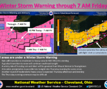
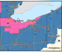
Things have changed since yesterday’s NWS Briefing. Wood County is now under an Ice Storm Warning from 1 p.m. this afternoon (2-12-25) through 7 a.m. Thursday (2-13-25). I believe the last time we had ice forecasted at this level was February 2019, so this is an atypical event.
There are several challenges in forecasting the event: from onset of precipitation, temperature at the time, and tracking. In addition, the models used by the various meteorologists are notably varied with a few outliers giving higher, more concerning numbers.

All the models are showing some precipitation in the area around noon with freezing rain around 3 p.m. This is expected to cause issues on the roadways when schools are letting out and the commute home for most of us.
The wintery snow mix will continue to about 2-3 a.m. with minor snow accumulations ending by around 4-5am.
In speaking with NWS Cleveland, the mean amount for ice accumulation between the models is 0.25”, but 0.30-0.34 is a possibility. One model shows 0.45” of ice accumulation, but currently that number is considered an outlier. At these temperatures, a simple 1-2 degrees F can make all the difference.
With all the information we are receiving, I would anticipate this ice storm will be worse than last week and will take longer to get the roads in good condition. Wood County has great community, county, and state road crews. If we can keep people off the road and let them do their job, they should be able to get the roads back to good condition by 9-10 a.m.
Now is a great time to reschedule early morning appointments or delay opening businesses, if possible, even just for an hour or two. Remember, road conditions may improve with treatment and time, but remember that untouched or just-treated sidewalks and parking lots may be problematic. It will take time for the de-icing agents to work.