By JULIE CARLE
BG Independent News
As America prepares to celebrate the 250th anniversary of the signing of the Declaration of Independence, history takes a front-row seat across the country and locally.
One of Wood County’s enduring stories dates to the Public Land Survey System that was created by the Land Ordinance of 1785, but was not implemented locally until after the War of 1812 and the 1817 Treaty of Fort Meigs.
“The remnants of the land survey are all around us,” said Chase Fleece, historic agricultural specialist with the Wood County Park District.
The very square, very mathematical system for divvying up the land into parcels has remained the lay of the land for over 200 years in Wood County and northwest Ohio.
The Public Land Survey System (PLSS), which was used for much of the country west of the original 13 colonies, divided land into 36-square-mile townships, which were then subdivided into 36 one-square-mile sections.
Today, the PLSS shows up as an invisible grid beneath our landscape, dictating the straight lines of many rural roads, property boundaries, and farm fields. It is the rectangular patterns often seen from the air.
Fleece provided some of the history behind the townships and sections that are the foundation for land ownership records and maps.
A look back
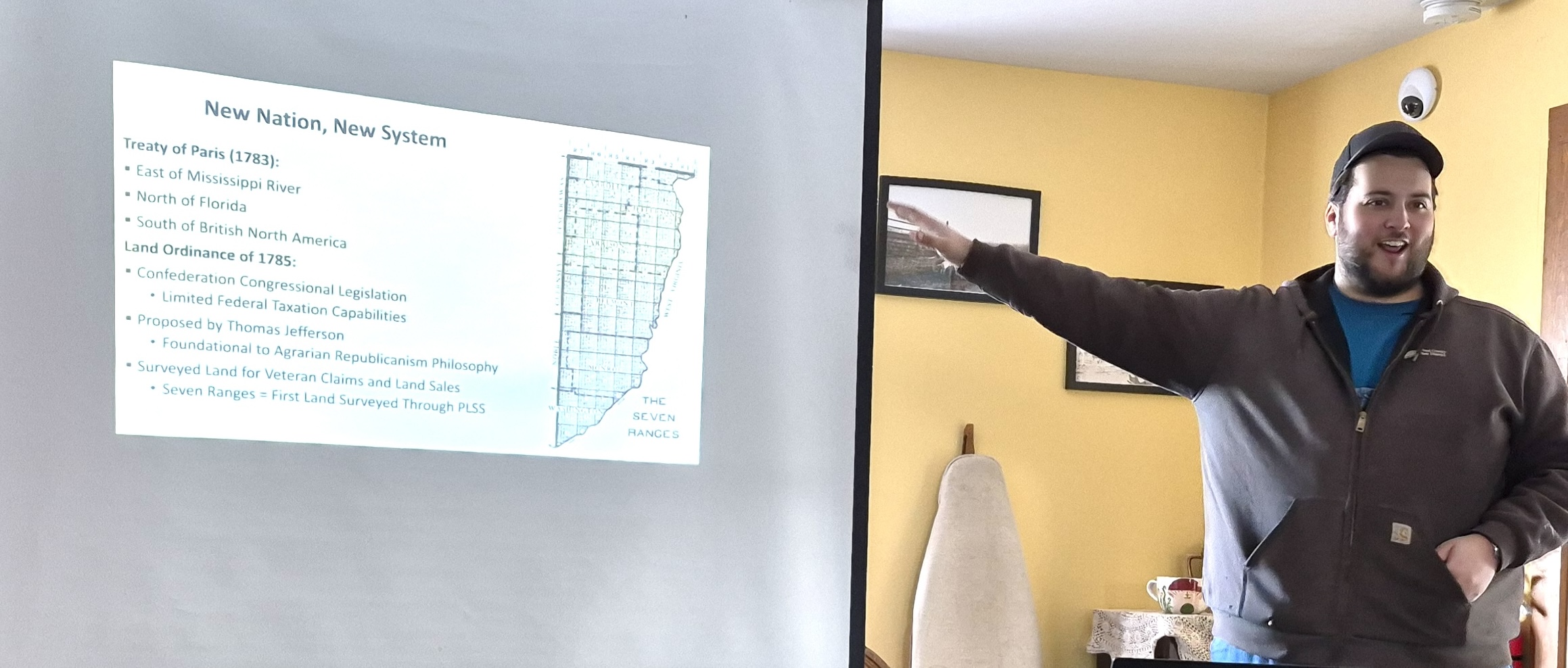
After the American Revolution, Americans were given all the land east of the Mississippi River, all land north of Florida, and the land south of what is now Canada. The Land Ordinance of 1785 was spearheaded by founding father and future president Thomas Jefferson.
Jefferson had a vision to open all the new land for “Yeoman farmers,” Fleece said. “It was his political philosophy, called agrarian Republicanism.”
Jefferson wanted every American to live on a farm and be a farmer. “We’re going to expand from the East Coast to the West Coast and everybody’s going to toil on the land,” Fleece said, summarizing Jefferson’s philosophy.
Because of his vision, Jefferson urged the Confederation Congress to create a system to mathematically divide the new territory.
The reality at the time was that the Confederation Congress was in debt from fighting the American Revolution.
“They were indebted to the French. They were indebted to the Spanish,” Fleece said about the philosophical and political motivations behind the land survey system. “Jefferson said, ‘Not only can we divide the land and give some of it to the veterans of the American Revolution, but we can divide it and sell it to make our money back and pay our debts.’”
In 1790, the first section of land surveyed was in Ohio in the area called the seven ranges between Pennsylvania and what was then called the Northwest Territory. The seven ranges includes the land that is now Belmont, Carroll, Harrison, Jefferson, Monroe and Washington counties.
Northwest Ohio was not included in the surveys until much later because “all the land the United States acquired was not uninhabited. There were Indigenous tribes in the Ohio territory,” Fleece said. “When Jefferson wanted to start segmenting the land in those territories, the Native Americans had a different idea. It is their land, and they’re going to defend it.”
The Northwest Indian War between 1786 and 1795 was the first conflict that delayed the land survey in some parts of the state. “It’s fought right here where we’re standing,” he said.
The 1817 Treaty of Fort Meigs, after the War of 1812, was the pivotal event that opened northwest Ohio for surveying and settlement.
Surveying started in about 1820 in this region, despite the area being considered the Great Black Swamp. Surveyors used a 66-foot chain to measure distances and kept detailed notes on the landscape, focusing on tree species and diameter, which served as indicators of land quality for potential buyers.
Ironically, the wetness of the Great Black Swamp was often noted as “Land not worth much. Too wet.” whereas today, the swampy area of the 1800s is not among the most productive farmland in the state, Fleece pointed out.
“They’re not only doing this to segment the country, but they’re also doing it as a marketing tool,” Fleece said about the detailed notes referencing the trees and the land on the surveyors’ notes to promote the land to eastern buyers.
Surveyor’s notes paint a picture of the past
The presentation included a hands-on activity where attendees analyzed copies of original 1821 surveyor’s notes to map out the historical landscape of the section they were in.
Copies of the original surveyor’s notes are invaluable primary sources that “provide an ecological snapshot of the pre-settlement landscape and serve a dual purpose as a survey record and marketing document,” Fleece said.

The surveyor’s notes were written in beautiful, old-time cursive, posing some difficulty in deciphering some of the abbreviations and the old-fashioned writing style.
The 10 participants worked as a group to create a section map based on the notes from 1821.
As the surveyor measured and took notes, he identified numerous cottonwood trees, several sycamores a black ash and an oak in the land that is now part of Center Township.
The local context made the historical events and the hands-on analysis of surveyors’ notes relevant to the audience.
Fleece’s presentation revealed the trend of using historical survey data as a tool for modern ecological analysis, allowing historians and scientists to reconstruct pre-settlement landscapes
He also highlighted a growing public interest in discovering the deep history of a specific place, such as one’s own property, by using digitized historical records like the surveyor’s notes to understand what existed 200 years ago
To look at individual property, Fleece suggested using the website randymajors.org.
“With this information, maybe you could go home, find the surveyor notes online to see what your property looked like 200 years ago, what trees were there and what kind of land was there,” he said. “This can kind of help you know what the land looked like before anyone was here.”