By JAN LARSON McLAUGHLIN
BG Independent News
Bowling Green City Council is hoping its resolve can turn into results if a Complete Streets ordinance is adopted.
Complete Streets refers to the concept that streets should be safe and usable for all – motorists, bicyclists and pedestrians.
Last week, City Council approved an appropriation of $6,300 to hire a firm to update the portion of the 2008 Master Transportation Plan that includes a consolidated bicycle treatment map and guidance.
The firm would utilize existing traffic data, roadway data such as lane widths and speed limits, plus community and bicycle treatment survey results from the Bicycle Safety Commission to develop and update a consolidated bicycle treatment map that will connect destinations.
The goal is to help the city’s on-going efforts to create a consolidated bicycle treatment map that could be codified by council and inserted into the planning process of the various paving projects.
In 2015, the city adopted a resolution supporting Complete Streets. A resolution does not carry the force of law, but council member Sandy Rowland explained that passing the resolution was as far as council would go in 2015.
Council member Rachel Phipps, who had previously circulated a model complete streets ordinance and draft policy, reminded council members that they had set revisiting Complete Streets either as a policy or an ordinance as a priority.
Council member John Zanfardino asked that a model ordinance be sent to City Attorney Mike Marsh – as Zanfardino had hoped in 2015. From there, the proposed ordinance would be sent to council’s transportation and safety committee.
Council member Bill Herald suggested that city officials quit pedaling the course originally planned for Complete Streets, and instead look at a possible new direction. The goals may have shifted over time, he said.
“We need to take a step back and have a community discussion of where we would like to go with Complete Streets,” Herald said.
The city should adopt a balanced approach to Complete Streets, rather than take steps that are drastic or invasive, he said.
The city adopted a long range plan in 2007, identifying several streets to become more bike-friendly. The city later embraced Complete Streets as a concept that calls for roads to be safe and accessible for all modes of travel.
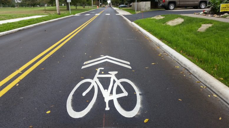
The options include bike paths, which are paved areas separate from the roadway; bike lanes, which are lanes specifically for bikes along the edge; sharrows, which use paint on the pavement to remind motorists to share the road with bicyclists; or signs posted alongside the road suggesting drivers to share the pavement.
After the original bike lane map was drawn in 2007, any efforts to modify the roadways appeared to stall out, except for the posting of signs along the roads. For nine years, the map came up occasionally, but the expense or inconveniences seemed to prevent modifications for bicyclists.
Then along came the Complete Streets effort, which seemed to breathe new life into efforts to make Bowling Green streets accommodating to more than just motor vehicles.
Grandiose plans were envisioned, with many streets identified as possible “bike routes” around the city.
In 2016, it was decided that efforts to add accommodations for bicycles must come earlier in the planning process. The timing problems came to light when decisions about Conneaut and Fairview avenues had to be rushed due to bidding requirements.
The city considered widening Conneaut and making lanes for bicyclists the entire length of the street. The option of creating a bike lane on Fairview fell out of favor early on because of logistical problems with neighbors and the golf course.
Ultimately, the decision was made to forgo the street widenings and add sharrows instead.
Then last year, sharrows were added to Thurstin Street and Manville Avenue. Two other streets – Clay and South Maple – were in line for paving and were recommended to get sharrows by the city’s Bicycle Safety Commission.
While Clay Street was a low priority for the bike commission, Maple Street ranked high for bike accommodations since the street links Bowling Green City Park with the Slippery Elm Trail.
But later in 2020, Bowling Green City Council’s Transportation and Safety Committee put those bike sharrows on hold in order to save parking on Clay and Maple streets.
The latest casualty for possible bike accommodations is on East Wooster Street, which will be paved this year from Campbell Hill Road to the CSX railroad tracks, using funds from the Ohio Department of Transportation.
In 2019, the city’s Bicycle Safety Commission suggested that Bowling Green explore bike lanes on seven streets – with East Wooster being one of those.
But it was determined that adding bike lanes on East Wooster Street would create problems for vehicular traffic, and adding a bike path would necessitate costly changes.
Also at last week’s City Council meeting:
- Planning Director Heather Sayler presented an update on the city’s zoning code changes. She also reported the zoning permits were up by 40% compared to last year. So far this year, 215 zoning permits have been requested, compared to 150 at this time last year. A total of 14 single family residence permits have been requested, compared to 10 last year.
- City Attorney Mike Marsh praised the appearance of Oak Grove Cemetery on Memorial Day. “It’s the nicest looking cemetery in Northwest Ohio,” he said, complimenting the city crew that maintains the property.
- Council member John Zanfardino reported the next rental housing meeting will be July 22, at 5:30 p.m., in council chambers.