
From WOOD COUNTY EMERGENCY MANAGEMENT AGENCY
Per the USEPA AirNow app, the AQI is over 500 throughout Wood County. As the front moves in from the southwest later today, July 17, it is expected to push the smoke northeast out of the area.
After the front moves through, the AQI will improve. However, it is expected to remain in the unhealthy range, which may impact those with underlying health issues.
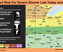
Today, temperatures will be in the mid- to upper-80s with a heat index in the low 90s. Thunderstorms are expected to arrive after 5 p.m. and may continue in to the early morning hours. Damaging winds in excess of 60 mph, frequent lightning, and heavy rain can be expected.
All of Ohio is currently under a “slight risk” (2 of 5) for severe weather tomorrow, July 18. The best chance of severe weather will be late afternoon, early evening. Damaging winds in excess of 60 mph, frequent lightning, and rain can be expected.
Saturday will have persistent and strengthening southwest wind with gusts up to 30 mph outside of any storms.
Wood County EMA will continue to monitor the AQI and weather conditions, providing updates as deemed appropriate.