The Wood County Emergency Management Agency has issued the following advisory:
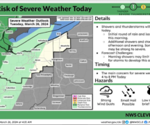
Southern Wood County is under an “Enhanced” (3 of 5) risk for severe weather while northern Wood County is under a “Slight” (2 of 5). Overnight the Enhanced risk has moved north slightly adding more of Wood County to the Enhanced risk area.
Today’s severe weather potential will be in two rounds. The first round of showers and thunderstorms are expected between 3-5 p.m., followed by a short period of clearing-dry conditions. At this time, there are signs these storms are weakening, however with the timing it has the potential to impact school dismissal and the evening commute.
The second round will move through our area around 7-9 p.m. These storms will be stronger, and all severe weather threats will be possible including unusually large hail, damaging winds and an isolated tornado is possible. Low-level shear from the warm front and some upper atmosphere ingredients will allow evening storms to develop into supercell type storms. A few additional showers may be possible through midnight, but no impacts are expected. Rainfall amounts are expected to be 0.35-0.45”, but with the rain over the past few days, localized flooding is possible.
Various weather services we interact with, agree that the threat of hail is the most likely threat. It would be advisable to protect all outside property or move inside for this weather event.
High winds of 70 mph are also possible which could cause downed electrical lines and power outages.
NWS Cleveland and NWS Storm Prediction have southern Wood County in a greater chance for EF2 or greater tornadoes should they occur. The current front is expected to move northward into Hancock County and along this front is expected to be the most severe weather.
We are encouraging everyone to take the following steps to make sure you are prepared:
- Have multiple ways to get emergency notifications such as: CodeRED Wood County’s Mass Notification System, NOAA Weather Radio, phone apps and local media.
- The link to sign up for CodeRED https://public.coderedweb.com/CNE/en-US/BFAB7B074BCD
- Have flashlights in your sleeping areas should the power go out.
- Have a location to seek shelter should the need arise.
- Secure any loose outdoor items.
- With the potential for high winds, tree damage as well as utility disruption can be expected and should be prepared for.