Brad Gilbert, Emergency Management Agency director for Wood County, has issued the following advisory:
2:45 p.m. Wednesday
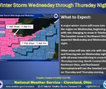
Updated forecast models indicate an influx of a little more cooler air at the surface and mid -levels of the atmosphere than originally anticipated on Thursday. As a result, the NWS has issued a Winter Weather Advisory from 5:00 a.m. until 7:00 p.m. on Thursday. Although total snow accumulations will be less than 1”, surfaces may become icy at times during the day especially on untreated surfaces. Please use extra caution when traveling or walking outside on Thursday as the potential for slippery conditions on and off throughout the day will be possible. Ice and Snow….take it slow!
….
From earlier Wednesday
A storm system moving from the south into the northeast on Thursday will bring a mixture of rain, sleet, and snow throughout the day and into the evening hours. Precipitation will begin in the morning around or just after sunrise and continue through the day into the evening hours. Accumulation of snow will be minimal, ½” or less, however surfaces may become slippery in the evening hours as temperatures drop, so use extra caution if traveling.
Long range forecast models do indicate a slight warming (back towards normal temps) next week and into the last week of November.