Erin Konecki, Emergency Management Agency deputy director for Wood County, has issued the following advisory:
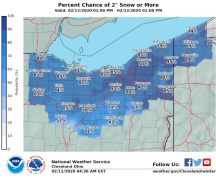
A Winter Weather Advisory is in effect for Wood County starting tonight from 1 a.m. to 10 a.m. Saturday morning. Snow should enter NW Ohio around 12a Saturday and should last about 3 hours. Snow will move through quickly.
- Friday night into Saturday morning: Light snow arrives early Saturday (Bowling Green is forecasted to have 1-2”) , transitioning to a freezing rain/wintry mix Saturday morning then to rain Saturday afternoon. Accumulated snow will likely melt during the day Saturday as “warmer” temperatures (up to 37 degrees F) and rain move in.
- Light glaze of ice around 0.02 of an inch is possible across the region during the transition periods Saturday morning and Sunday.
- Rainfall amounts will lead to river rises Saturday night and Sunday, with a few points potentially experiencing minor flooding. Ice jams will need to be monitored as rivers rise.
- Sunday morning: rain will transition back to snow (Bowling Green is forecasted to have 3-4 additional inches with the heaviest mid to late Sunday morning).
- Below zero wind chills expected Sunday night and Monday morning with wind gusts over 30 MPH.
- Monday: will be extremely cold, temperatures forecasted at 15 degrees F at 6am with a windchill at -3 degrees F.
Expect slick conditions on some roads and other untreated surfaces including driveways and sidewalks during the wintry mix early Saturday, with snow covered roads and blowing snow after the change back to snow Sunday into Sunday night.