Jeff Klein, Emergency Management Agency director for Wood County, has issued the following advisory:
Wood County is expecting severe winter weather starting Wednesday Feb. 2 through Friday Feb. 4.
Overview:
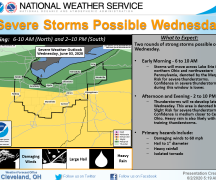
During the daytime Tuesday (Feb. 1) temperatures will rise in the lower to mid-40’s. Rain is expected to begin at approximately 7 p.m. and continuing through Wednesday morning. At this time, it appears between 7 a.m. and 9 a.m. there will be a brief period freezing rain switching over to snow. It is expected for Wood County the switch from freezing rain to snow will happen relatively quickly. The currently information from NWS Cleveland shows only a half inch of snow until about 7 p.m.. Between 7 p.m. and 7 a.m. 4.5-5” of snow is expected. An additional 6” can be expected between 7 a.m. and 7 p.m. on Thursday. The current model shows snow continuing after 7 p.m. Thursday but diminishing with no estimated snow fall amounts at this time. Thursday afternoon into Friday temperatures will drop into the teens and below zero temperatures with wind chills up to -16F.
Hazards:
Wednesday: Expect hazardous travel conditions Wednesday morning due to freezing rain.
While it is expected to change from rain to freezing rain to snow quickly, there is a potential for ice conditions to worsen. This could make roads conditions more hazardous, and it also increases the potential of down trees and power lines.
Expect travel delays on roadways throughout the day with increased delays during the peak travel times.
Thursday: With the projected snow fall on Thursday, road crews will be challenged to keep the roads open.
Expect country roads along open fields to impassible.
Expect non-essential businesses to be closed.
As we have seen in other states over the last few weeks, major travel routes could become impassible at times.
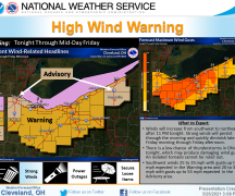
Friday: High winds from the NE will create drifting and blowing snow.
Recommendations
Prepare as you may NOT be able to travel Thursday and Friday. Make sure you have needed supplies: food, water, generator fuel, etc. available by Tuesday.
Do not travel if you do not need to. Road crews can get the roads clear quicker if they don’t have to work around stuck vehicles.
Top off all fuel tanks.
Regardless of the snow level, make your decisions based on your situation, vehicle (SUV vs compact), location (country vs city road) and your skill/comfort level.
Prepare for potential power outages: flashlights with fresh batteries, keep cell phones and spare power packs charged, food, blankets, hats gloves, etc.
If you are older or have pre-existing medical conditions, use a snow blower or have someone else clear your property. The cold constricts your blood vessels then add the strain of exertion of shoveling which increases your chances of a heart attack.
Monitor local media for weather conditions.
Sign up for CodeRED for emergency notifications: https://public.coderedweb.com/CNE/en-US/BFAB7B074BCD
Download weather apps for continued updates
Monitor NWS Cleveland for updates at https://www.weather.gov/cle/ . For a better detailed forecast for your location go to https://forecast.weather.gov/gridpoint.php?site=cle&TypeDefault=graphical and click on your general location on the map.
If this weather event continues as expected and you have an emergency, the delay to get help could be substantial. First responders must deal with the weather like everyone else. For this reason, we encourage you to take advantage of this time and think about what your needs will be. While many of us are not overjoyed with this forecast, the advantage is we have the time to prepare.