The Wood County Emergency Management Agency has issued the following advisory:
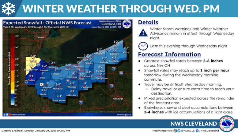
NWS Cleveland provided an update this afternoon with only a few timing changes.
Timing: The overall timing of early Wednesday morning is estimated to be around 3 a.m., freezing rain is expected to start transitioning to snow around 5 a.m. No significant ice accumulation is expected. Snow accumulation of 4.2 inches between 7 a.m. to 1 p.m., 2.3 inches between 1-7 p.m., with approximately 1 inch overnight. Light snow showers are expected to continue throughout Thursday morning. This snow event is expected to produce snow just under 8 inches total.
Concerns:
- With the temperatures being near 32F, icy roads can be expected Wednesday morning.
- Wednesday morning commute could have a snow fall of 1 inch per hour.
- Winds gusts 20-25 mph will cause blowing snow and drifting.
- The afternoon commute will be a wintery snow/rain mix.
General Precautions:
- If you can, reschedule your plans so you do not need to be traveling Wednesday.
- If you must travel, monitor conditions and road reports.
- Clear your car/windows of ice and snow before leaving.
- Have your car safety kit ready: food, water, blanket, shovel, sand/cat litter, reflectors, first aid supplies, flashlight, ice scraper, jumper cables.
- Keep your cell phone charged.
- Make sure someone knows your estimated route and drive times.
- Keep your fuel tank at least half-full.