Here’s latest from National Weather Service as shared by Wood County Emergency Management Agency:
What to expect:
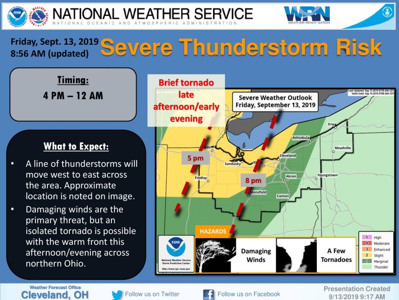
1) A warm front will move northeast across northern Ohio today. Any storms that can develop along this boundary could produce a brief tornado.
2) Otherwise, a scattered to broken line of thunderstorms is expected to develop over Indiana or NW Ohio during the late afternoon and evening. The attached image
indicates where this line of thunderstorms may be located around 5 pm and 8 pm. These storms will be capable of producing strong damaging winds.
3) Windy conditions area expected to develop across portions of NW Pennsylvania late this afternoon into the overnight hours (outside of thunderstorms). These southerly winds
will mainly impact Erie County, Pennsylvania from near I-90 to the lakeshore. The area is highlighted where the strongest winds should occur on the attached map. This is the region where winds may gust up to 50 mph.
What has changed:
The Storm Prediction Center’s Slight Risk area for severe thunderstorms (primarily damaging wind) has been expanded east and south and now reaches Cleveland and the western suburbs and the US 30 corridor. The area with the tornado risk has also expanded to include all of northern Ohio.
The following links can be bookmarked for the latest information:
Updates from the Storm Prediction Center can be found at www.spc.noaa.gov/
As storms develop, Local Storm Reports can be found here.
The latest forecast for your location can be found by clicking on the map at www.weather.gov/cle.