The Wood County Emergency Management Agency has issued the following advisory:
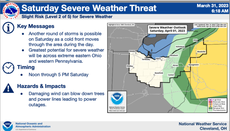
The Storm Prediction Center has Wood County under a “Marginal Risk” for severe weather today (Friday, March 31).
A front will be moving through today bringing us three (3) rain events. The first will begin early afternoon with steady rain up to 0.2”.
The next rain will begin early evening with the possibility of thunderstorms. The front is expected to move fast through Wood County around midnight with thunderstorms forecasted. Wind gusts of 50-60mph will be the primary concern. The chance of rain will remain though Saturday evening. Due to the drop in temperature, a snow/rain mix is possible but not expected to have major impacts. Saturday winds are expected around 30mph with gusts up to 45mph.
Nighttime storms are always a concern for us due to people sleeping and limited visibility due to the darkness. We are encouraging everyone to take the following steps to make sure you are prepared:
- Have multiple ways to get emergency notifications (CodeRED Wood County’s Mass Notification System, NOAA Weather Radio, phone apps and local media).
- The link to sign up for CodeRED: https://public.coderedweb.com/CNE/en-US/BFAB7B074BCD
- Have flashlights in your sleeping areas should the power go out.
- Have a location to seek shelter should the need arise.
- Secure any loose outdoor items.
With the potential for high winds, tree damage as well as utility disruption can be expected and should be prepared for.