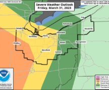
The Wood County Emergency Management Agency has issued the following advisory:
Areas of rain showers with the potential for thunderstorms are expected into early afternoon.
A more organized system may move through Wood County in the early to midafternoon. Some of these storms may have the potential to produce hail, strong winds, frequent lightning and locally heavy rain.
Additional scattered showers and thunderstorms may develop later this afternoon into this evening along and ahead of an advancing cold front. These storms have the greatest potential to produce severe weather. The main threats are large hail, strong damaging winds, frequent lightning and locally heavy rain. An isolated tornado is possible. A few showers may linger through the overnight hours into Friday morning.
As these storms have the potential to occur during the evening commute, we recommend checking weather conditions before leaving and having multiple ways to receive emergency notifications in the event a warning is issued.