The Wood County Emergency Management Agency has issued the following advisory:
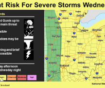
The northern portion of Wood County has been upgraded to a “Slight Risk”. Grand Rapids diagonally south to Fostoria has been upgraded two levels to “Enhanced Risk”.
There is a risk of strong storms throughout the evening, but the main hours of concern will be from 10pm-2am tonight. Wind gusts of 45-65mph could be possible with the strongest of storms, along with a threat for a few isolated tornadoes.
This weather event has been rapidly evolving, making it more challenging to forecast. Considering how fast as it has been evolving, it does give us concern that this event could be much stronger than previously thought.
With the elevated threat, it is even more important to be prepared before going to bed. We are encouraging everyone to take the following steps to make sure you are prepared:
- Have multiple ways to get emergency notifications CodeRED Wood County’s Mass Notification System, NOAA Weather Radio, phone apps and local media. Make sure you have the volume up so it will wake you up.
- The link to sign up for CodeRED https://public.coderedweb.com/CNE/en-US/BFAB7B074BCD
- Have flashlights in your sleeping areas should the power go out.
- Have a location to seek shelter should the need arise. It would be a good idea to prepare that area with supplies just in case you need to take shelter.
- Secure any loose outdoor items.
With the potential for high winds, tree damage as well as utility disruption can be expected and should be prepared for.