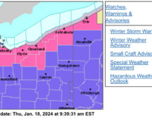
The Wood County Emergency Management Agency has issued the following advisory:
NWS Cleveland has Wood County under an “Enhanced” Risk (3 of 5) for severe thunderstorms Wednesday evening.
The estimated time for the system moving through Wood County will be between 9 p.m. and 11 p.m. It will a fast-moving system, brief heavy rain with a brief flashflood potential. Severe hazards include damaging wind gusts and large hail. There is some tornado risk with this system, but this is not being considered a primary threat.
Storm intensity and coverage will be dependent on the formation of small clusters of storms before this event. If these small clusters do develop before the forecasted storm, this would likely benefit us and could end up stabilizing the atmosphere. This could mean a reduced severe impact of the late evening storms.