By JAN LARSON McLAUGHLIN
BG Independent News
Farm experts are predicting that 90 percent of the farm crop in Wood County will go unplanted this year.
Saturday’s drenching rains – dropping 5 inches of rain in some areas of the county – have placed local farmers in uncharted territory. They were already hurting from unprecedented wet weather this spring. Then Saturday hit.
“I don’t think there’s any area in Wood County that will be dry by June 5,” which is the deadline for farmers to decide whether they will take a chance on planting corn or purchase crop insurance, said Alan Sundermeier, agent at the OSU Extension Office in Wood County.
“I would be looking at 90 percent of the corn not being planted in Wood County,” Sundermeier said Monday morning.
Though Monday and Tuesday are expected to be dry, more rain is forecasted for Wednesday.
“This is uncharted territory,” Sundermeier said.
Paul Herringshaw, of Liberty Township south of Bowling Green, was one of many local farmers who watched in dread as the dark storm clouds rolled in on Saturday. He and his son were out looking at their fields on Saturday morning, and decided they could possibly get planting equipment in on Sunday or Monday.
The storm looked threatening to the north – but appeared that it might skirt past Wood County.
“You could see it up north, and thought it was going to miss us,” Herringshaw said.
But once it started raining, it didn’t let up for hours – until it had dumped 2.75 inches on Herringshaw’s land.
“It was kind of heartbreaking,” he said.
“I have never been in this situation before,” Herringshaw said. “This is one time I’m definitely glad I have crop insurance.”
But Herringshaw pointed out that crop insurance is a poor substitute for producing a crop. It can allow farmers to break even, but not move ahead.
“It is very frustrating,” he said. “My goal is to produce a crop. That’s how I make my money.”
Herringshaw and his son were able to plant about 25 acres of corn a little over a week ago since they have some high ground on a sandy ridge. But now he is likely pinning his hopes on soybeans, which can be planted later and still produce a healthy crop.
“Every farmers’ situation is going to be a little different,” he said.
Those raising livestock, who grow their own feed corn, will likely be hurting this year.
“That presents a whole other group of challenges,” Herringshaw said.
And then there’s the effect all this rain has on the soil. Farmers have noticed that the constant wetness somehow changes the soil structure.
“The ground doesn’t react the same after you get all this wet weather,” he said.
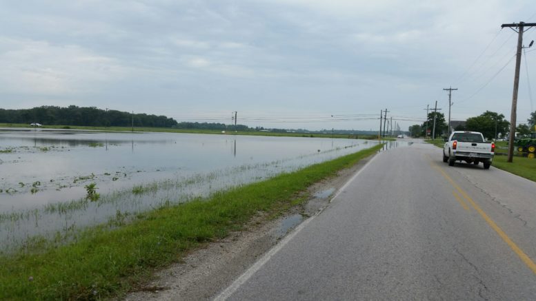
Though the agricultural community is the most seriously affected, Saturday’s heavy rains are also causing inconveniences for others in Wood County.
The county highway garage has shut down some flooded roads, including Euler between Custar and Wapakoneta roads, North River between Wayne and Zepernick roads, and East Gypsy Lane between Dunbridge and Huffman roads.
Several other county roads remain open but have “high water” signs posted, according to Jerry Houtz, of the county highway garage.
“That wasn’t your normal thunderstorm. That was definitely out of the ordinary,” Houtz said of Saturday’s downpour. As of Monday, “most of the ditches and small tributaries are down,” he said. However, the worst is probably yet to come along the Portage River.
Wood County Emergency Management Agency Director Jeff Klein said so far high waters have affected land and roadways – but he expects some of the flooding to hit structures before the water recedes.
“I think it’s going to happen by time all that water comes through,” he said, noting the heavy rainfall in the Findlay area on Saturday. “All that is coming to us” as it makes its way to Lake Erie.
Klein advised that motorists be careful driving on roads that are at risk for high water. Sunday as he was touring the county, he observed quickly changing conditions, and actual “turbulent water” across some roads.
“Conditions change. I think people really need to be cautious. We’re in a dynamic few days,” he said. “Plan for it getting worse.”
One of the areas waiting for the full impact of the heavy rains is Pemberville, where two branches of the Portage River merge in the downtown area.
High waters have closed Water and Bridge streets, and several township roads, Pemberville-Freedom Township Fire Chief Duane Martin said Monday morning.
“As far as we know, nobody has evacuated and we haven’t had to do any water rescues,” Martin said.
The high water has not reached the businesses in the downtown – but the fire department is watchful.
“It still is creeping up. It hasn’t crested yet,” Martin said. “We’re keeping an eye on it.”
Some streets in Bowling Green also saw some brief flooding on Saturday, according to Joe Fawcett, assistant municipal administrator.
“Like anywhere else, when there’s an inundation of water that needs to go somewhere,” Fawcett said. “Backyard flooding has been occurring and that’s normal when this amount of rain has fallen.”
The heavy rain also caused the city’s wastewater treatment plant to have an overflow. During such heavy rains, the volume of stormwater entering the combined sewer system can exceed the capacity of the plant. When this happens, combined sewers are designed to allow a portion of the untreated combined wastewater to overflow into the ditch on East Poe Road. This prevents the backing up of sewage into basements, and flooding of streets.
Every time this overflow occurs, it must be reported to the EPA since it allows untreated human and industrial waste to go into the ditch.