The Wood County Emergency Management Agency has issued the following advisory:
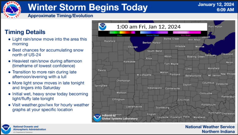
Rain is likely to begin late morning (1-12-24), early afternoon switching to snow after midnight. There is a possibility of intermittent periods of sleet and snow between 4 p.m .and 8 p.m. Expect rainfall to be 0.5-1.0 inches, snowfall potential 1-4” with the highest totals in the Grand Rapids- Haskins- Perrysburg areas. Minor flooding and ponding is possible.
The biggest concern will be the high winds, low temperatures and wind chills. The wind speeds will be increasing throughout the day peaking to 50mph overnight though 8 a.m., decreasing to 40mph during the day Saturday. As the front moves in, temperature will drop to the mid 20’s F with wind chill below 10F. Sunday through at least Wednesday the wind chill remain below zero with near -20F early Monday morning. With the cold and high winds, localized power outages are possible.
We can expect temperatures next week to be below normal with low wind chills.
Considerations
Make sure cell phones are charged and flashlights are working with good batteries
Dress in layers, limit outdoor exposure.
Do not use generators inside buildings including garages even with the door open.
Make sure your vehicle is in good working order with winter supplies: jumper cables, ice scraper, cell charger, cat litter for traction, food, water, and blanket.
Disconnect outdoor hoses, wrap exposed water lines and monitor for broken interior water lines.
Keep furnace vents clear to prevent carbon monoxide build up in your home.
Do not leave pets outdoors, be careful of ice melting chemicals and wipe paws if deicing chemicals or ice is present.