Jeff Klein, Emergency Management Agency director for Wood County, has issued the following advisory:
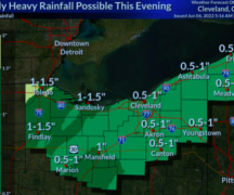
The Storm Prediction Center (SPC) has Wood County in a “Slight Risk” for severe weather expected to begin around 8 p.m. and into the overnight hours. What is import to note is Wood County is on the eastern edge of “Enhanced Risk” in the counties to our west. If the storms build, it could increase our risk of severe weather. The SPC has possible tornados in the “Enhanced Risk” which has the possibility to extend into Wood County.
An incoming storm system capable of producing Supercell thunderstorms are possible later today as they fire along a warm front over Illinois and Indiana, move east into northwest Ohio late in the day, and continue eastward overnight. Damaging wind gusts will be the primary threat accompanying these storms. Favorable wind profiles support the development of tornados. Potential threats for Wood County include downed trees, power-lines, and property damage as a result of hail, high winds and possible tornadoes.
Please monitor local weather conditions and media for the most up-to-date information. The Wood County EMA will be monitoring and provide updates as they are available.


