The Wood County Emergency Management Agency has issued the following advisory:
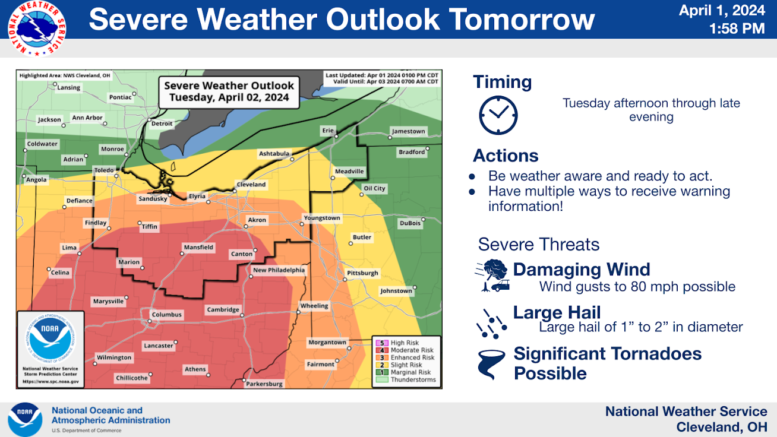
There has been a significant increase in the severe weather threat issued for tomorrow (Tuesday April 2, 2024).
The northern portion Wood County has been placed under a “Slight” (2 of 5) and south of US6 area is under an “Enhanced” (3 of 5) chance of severe weather. This threat carries the potential for all severe weather aspects with damaging wind gusts, damaging hail, and tornadoes possible.
Scattered showers will begin developing tonight and will transition to widespread showers tomorrow. The showers tomorrow (Tuesday) will bring with them 35-45mph wind gusts throughout the earlier portion of the day as a cold front pushes across the region. A risk of strong to severe thunderstorms will move through Tuesday afternoon (estimated most likely around 5pm-9pm) with locally heavy rain, frequent lightning, 1-2” hail, and wind gusts exceeding 60mph possible. The timing of this would most likely affect the evening commute and potentially impact school dismissals.
At this time, central Ohio is under a “Moderate” (4-5) risk for severe weather. The Storm Prediction Center has in their summary for tomorrow: A potentially substantial severe weather outbreak – possibly including a few significant/long-track tornadoes — is evident for Tuesday afternoon and evening, with highest probability centered over the Ohio vicinity, and extending southward across the Tennessee Valley. This is a system to closely monitor on Tuesday.