Brad Gilbert, Emergency Management Agency director for Wood County, has issued the following advisory:
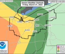
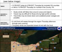
A sure sign of Spring is coming! The Storm Prediction Center (SPC) has place Wood County in the “Slight” risk category for severe weather on Thursday. A strong storm system moving through the Western Great Lakes will draw in much warmer air to Northern Ohio on Thursday. By late afternoon and early evening Thursday, a strong cold front will move into the area triggering strong to potentially severe thunderstorms. Damaging straight line winds will be the primary threat; however, there will be a small tornado threat as well. Forecast models indicate a line of thunderstorms will move into NW Ohio from Indiana in the 4:00 p.m. to 8:00 p.m. time frame on Thursday which is at the typical atmospheric destabilization time frame from the sun’s energy during the day.
Please monitor weather conditions closely Thursday afternoon and evening. Also, next week is Severe Weather Awareness Week in Ohio with the annual statewide tornado drill on Wednesday, March 20th at 9:50 a.m. The NWS will activate weather radio alerts and Wood County will activate the Outdoor Warning Siren System at that time. It is that time of year to review severe weather procedures both at home and at work and have a plan of action should the weather become threatening.
EMA will provide another update on Thursday with the latest information.