The Wood County Emergency Management Agency has issued the following advisory:
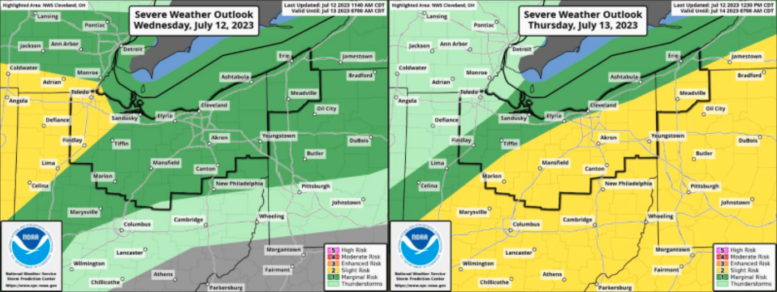
The National Weather Service Storm Prediction Center has placed all of Wood County in the “Slight Risk” (Level 2 of 5) for this evening. The forecast for Thursday has southern Wood County in the “Marginal Risk” (Level 1 of 5) but as always this could change.
The primary risk with the thunderstorms tonight will be strong and potentially damaging winds but keep in mind that an isolated tornado is also possible. One variable with this potential for severe weather is that with the cloud cover and earlier rounds of showers and thunderstorms, this could limit or disrupt development of the storms later tonight. Some of these passing storms may be strong to severe, with gusting winds 40-50mph and marginally sized hail.
The expected timing is 6pm-8pm for the first round and 10pm to 12am for a second.
We are encouraging everyone to take the following steps to make sure you are prepared:
- Have multiple ways to get emergency notifications such as: CodeRED Wood County’s Mass Notification System, NOAA Weather Radio, phone apps and local media.
- The link to sign up for CodeRED https://public.coderedweb.com/CNE/en-US/BFAB7B074BCD
- Have flashlights in your sleeping areas should the power go out.
- Have a location to seek shelter should the need arise.
- Secure any loose outdoor items.
With the potential for high winds, tree damage as well as utility disruption can be expected and should be prepared for.