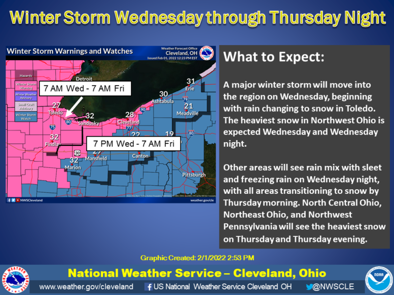
Jeff Klein, Emergency Management Agency director for Wood County, has issued the following advisory based on the Tuesday afternoon briefing from the National Weather Service Cleveland:
What has changed:
· The projected storm track has shifted southeastward slightly, which now favors more snow and less freezing rain and sleet for northern Ohio and northwest Pennsylvania.
· Total precipitation amounts have trended downward resulting in a slightly lower snowfall forecast.
What to expect:
· Rain will change to mixed wintry precipitation and eventually to all snow from NW to SE Wednesday through early Thursday morning
· Widespread snow should then end from west to east Thursday night through early Friday morning
· The greatest snow totals are still expected in northwest Ohio and along/near Lake Erie in north-central/northeast Ohio and northwest Pennsylvania
· The best chance for a wintry mix of sleet and freezing rain continues to exist south of US-30 and may impact snowfall totals in this area.
· The greatest uncertainty continues to involve the spatial extent of mixed wintry precip, especially freezing rain, and how much ice will accumulate from freezing rain
· Blowing and drifting snow and reduced visibility are expected at times, especially in Northwest Ohio. Northeast winds will gust as high as 30-35 mph in Northwest Ohio Thursday afternoon and evening.
· Regardless of the exact snow, sleet, and ice totals, major impacts to travel are expected Wednesday night through Friday morning
The following links can be bookmarked for the latest information:
Winter Storm details can be found here.
Additional information and snowfall graphics can be found at: www.weather.gov/cle/winter
The latest forecast for your location can be found by clicking on the map at www.weather.gov/cle.
Social Media and winter safety information can be found here and here.
National Weather Service Cleveland