From WOOD COUNTY EMERGENCY MANAGEMENT AGENCY
Over the next few days, people are encouraged to keep an eye on the weather. Much of the forecast, especially Wednesday evening, has the potential to be high impact. To receive customized weather alerts from Wood County Alert, visit the registration page and sign up at https://member.everbridge.net/76486388220118.
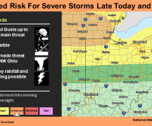
A marginal risk (level 1 of 5) has been issued for far northwest Ohio today, June 16. Isolated strong to severe storms are possible this afternoon into the evening. For the Wood County area, chances of thunderstorms will ramp up during the late day hours ahead of the cold front. Chances are 20% at 3 p.m. but increase to 40-50% by 6 p.m. Best chances of thunderstorms are expected this evening after 7:30 p.m. when the risk goes up to 70%. Storms are expected to be scattered but could contain wind gusts up to 45 mph.
For tomorrow, June 17, a slight risk (level 2 of 5) has been issued for areas west of the I-77 corridor for Wednesday. Multiple rounds of thunderstorms are possible, with the strongest storms expected in the late evening into the overnight hours.
All severe hazards are possible. Wood County is within an area hashed 5-9% probability of tornado within 25 miles. It is also within the 15-29% probability of severe wind within 25 miles and the 15-29% probability of severe hail within 25 miles.
Storms may produce heavy rainfall and localized flash flooding.
Strong winds are expected on Thursday, June 18, with gusts up to 45 mph possible.
The Wood County EMA will continue to monitor and provide updates as deemed appropriate.