Brad Gilbert, Emergency Management Agency director for Wood County, has issued the following advisory:
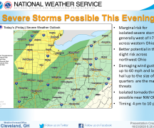
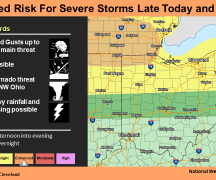
A break will develop late this morning and early afternoon from existing showers and thunderstorms. Thunderstorms will redevelop later this afternoon and especially this evening. Dynamics in the atmosphere today over NW Ohio will support the development of stronger to some severe thunderstsorms. It has been awhile since we have been in the direct target of strong/severe storm potential development. The SPC has NW Ohio in the “Slight” risk for severe weather today. Primary threats are damaging straight-line winds, large hail, and a chance of an isolated tornado as wind sheer will allow for some rotation in the atmosphere. Stronger storm potential will be this evening to possibly into the very early hours of Wednesday.
Please monitor weather conditions and local media/weather radios for the latest weather information and possible watches and/or warnings this evening.