Brad Gilbert, Emergency Management Agency director for Wood County, has issued the following advisory:
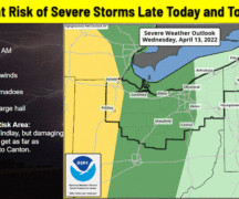
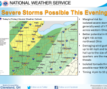
A strong cold front will move across Northern Ohio on Friday bringing showers and thunderstorms. Because of the strength of the cold front and the warm/moist air that will be in place over Northern Ohio, thunderstorms may become severe. The Storm Prediction Center has NW Ohio in the “Marginal” risk category for severe weather while area east and south of Wood County will be in the “Slight” risk category. Damaging straight line winds and hail will be the primary threats along with heavy downpours of rain. Timing of thunderstorm develop on Friday as of today incidates thunderstorms will likely develop and begin to strengthen over NW Ohio in the early-mid afternoon before moving east/south as more mature/stronger thunderstorms. Much cooler air will move into the area Friday night and into the weekend as Fall officially begins at 9:54 p.m. Saturday night.
As many on this email list are school officials with football games on Friday night, the timing at this point indicates thunderstorms will likely be out of the area by kick-off times. Some lingering showers may still be in the area; however, the lightning and severe weather threat should be well east and south of Wood County by football time. EMA will monitor forecasted conditions and provide an update Friday morning especially if timing changes and may impact football games Friday night.