By JAN LARSON McLAUGHLIN
BG Independent News
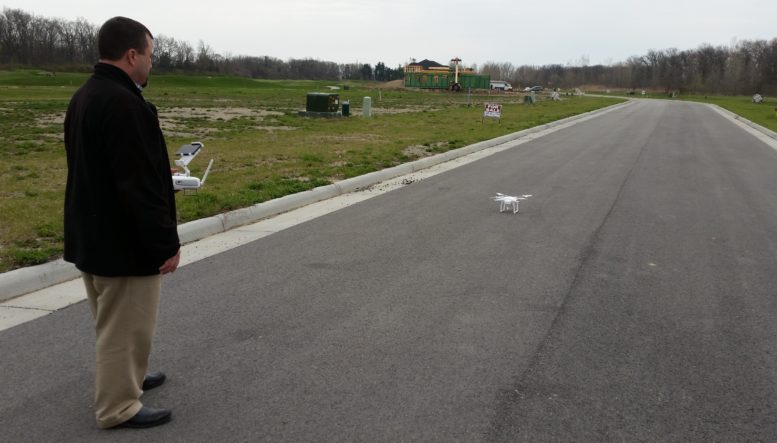
Sounding like a distant swarm of mosquitoes, the city’s drone took a test flight down Pine Valley Drive on Thursday afternoon.
The flight showed why Bowling Green intends to start using a drone to help with its infrastructure projects. The drone can provide up-to-date images for roadwork, water, sewer, or other utility projects.
In the past, the city has relied on aerial photographs taken for the Wood County Auditor’s Office. The problem, though, is that the photos are taken every two years.
“In between things change,” said Jason Heyman, the city’s Geographic Information System coordinator and unmanned aircraft system pilot.
For example, the street being surveyed from the air on Thursday was still under construction when the aerial photos were taken.
“This is a huge advantage to us,” Heyman said. Now, he will no longer have to answer the question, “Why aren’t these roads on your maps?”
Assistant Municipal Administrator Joe Fawcett said Google Earth satellite images show roads under construction long after they have been completed.
“It’s night and day,” Fawcett said.
Jason Heyman holds city’s drone.
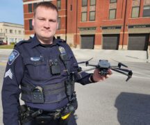
The drone came at no cost to the city. Bowling Green Police Division seized three drones during a reshipping fraud investigation, according to Major Justin White. The fraud involved a Bowling Green resident having merchandise shipped to him using hacked credit card numbers, then reshipping the merchandise elsewhere. The scheme was like money laundering for merchandise, White said.
The police and fire divisions kept one of the drones for each of their operations. The police are still working on developing a policy and looking into FAA requirements. The fire division is considering the use of the drone during major fires, to give firefighters a bird’s eye view, Heyman said.
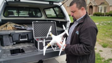
The drone, a Dji Phantom 4 Pro, which is approximately 6 inches tall with a wing span of 12 inches, is designed to take video or photographs. For the city’s GIS program, the drone will take a rapid series of photos that are then stitched together to make a smooth mapped image.
The process involves first identifying the area to be mapped – where an infrastructure project is planned. Then with a device, such as a smart phone or tablet, a rectangle is created around the area needed and set to a desired altitude. The drone takes off, captures the images, then returns to the pilot.
On Thursday, the three-pound drone flew an area the length of 800 feet on Pine Valley Drive, taking roughly 220 single images in 12 minutes. Those pictures will then be laced together to create a seamless map.
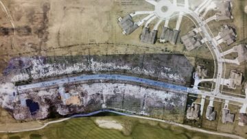
Pine Valley Drive view
Due to safety precautions, anytime Heyman pilots the drone, the street must be closed down for the duration, and residents along the route will be notified of the flyover.
The drone camera will point straight down so it will not take photos over private property, Fawcett stressed.
A typical flight for city projects will last up to 30 minutes with the drone mapping images captured at an altitude of 20–100 feet depending on conditions, Fawcett said.
The only expense for the drone program has been Heyman’s FAA training for piloting an unmanned aircraft system, costing $150. He will have to retest every five years.
Fawcett said he believes Bowling Green is the first municipality in Ohio to use a drone for engineering infrastructure projects. The first street that the drone will likely be used on in the city is a waterline project on Liberty Street.
According to Fawcett, the city must file a pre-flight plan to designate the route that will be flown. Those plans must go to the Wood County Regional Airport, Bowling Green State University and Wood County Hospital.