The Wood County Emergency Management Agency has issued the following advisory:
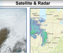
Wood County continues to monitor the incoming round of severe weather expected to impact our region between 5-10 p.m. We remain in an “Enhanced Risk” (Level 3 of 5) zone, which has been slightly extended to the west.
The National Weather Service (NWS) in North Webster, Indiana, maintains high confidence in the potential for severe weather. However, NWS Cleveland anticipates that these storms will begin to weaken as they enter Ohio, making the overall forecast for our region more complex.
Forecast Highlights:
- 10 a.m. to 1 p.m.: Isolated showers and possibly a thunderstorm are possible, though most activity should remain to our north.
- 4–10 p.m.: Scattered thunderstorms are likely as multiple storm lines pass through the area. Primary threats include wind gusts of 60–70 mph, with potential for large hail and an isolated tornado.
Additional Notes:
- Rain may continue through Thursday, with estimated totals up to 0.5 inches.
- We will continue monitoring conditions throughout the day and share updates as necessary.