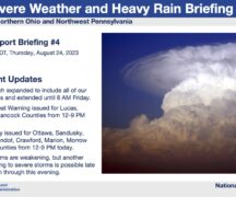
Brad Gilbert, Emergency Management Agency director for Wood County, has issued the following advisory:
EMA has just completed a webinar with the NWS Cleveland office. Although confidence is now high on the overall impact of this weekend’s storm, exact snowfall amounts still have a little question in the forecast. The forecasted storm track has moved just slightly further south than yesterday. Details are as follows:
SNOW AMOUNTS:
In general, Wood County will see an average of 4” of snowfall. Some uncertainty remains so total accumulations could be 1” to 2” more or even 1” less than the general 4” forecasted. Southern, especially southeastern Wood County will have the best chance to see a little more than 4” of snowfall.
TIMING:
Timing has also changed since last night. Some areas along or north of the Turnpike may see some light snow in the very early morning hours, but most of Wood County will not see snowfall until mid to late morning on Saturday. Forecast models now indicate that snow should move out of the Wood County area by midnight Saturday night.
WINDS:
Winds will start to increase Saturday morning and become strongest in the late afternoon and evening of Saturday into the overnight hours and Sunday morning. Winds will be from the northeast most of the time at 15-25 mph. There will be wind gusts 30-40 mph at times especially Saturday evening and into the overnight hours. Winds will start to subside late Sunday afternoon and into the evening, but will still be breezy.
IMPACTS:
Traveling difficulty will increase throughout the afternoon on Saturday. The evening hours are likely to have the most difficult travel conditions due to increasing winds. Travel will also remain difficult on Sunday as snow continues to be blown around by gusty winds. Winds may also cause sporadic power outages, so be prepared to deal with these issues should they occur. Dangerous cold air will move into the area for Sunday into Monday with Monday morning wind chills around -20 degrees F. Please check on family, friends, neighbors, and pets with this dangerous cold settling into the area.
A Winter Storm WATCH is in effect for Saturday. A Winter Storm WARNING has been issued just to our south and southeast as they will be receiving more snow than Wood County. The NWS will evaluate the forecast again late tonight to decide if Wood and Lucas Counties are to go under a Winter Storm WARNING or a Winter Weather ADVISORY. A warning is an indicator of at least 6” of snowfall, so if a warning is issued, expected snow totals will be up from the current 4” predicted.
From EMA, have a SAFE weekend and don’t venture out unless you absolutely have to. Let the plow drivers do their job to get our roads clear. If you have to venture out, remember ICE AND SNOW…TAKE IT SLOW!