Brad Gilbert, Emergency Management Agency director for Wood County, has issued the following advisory:
Per the latest forecast models and a brief conversation with the NWS Cleveland office, I am sending you the latest update of information concerning the winter storm for Monday and conditions for this weekend.
A Flood WARNING continues for MINOR flooding along the Portage River at this time. The river should go below flood stage Saturday morning.
Tonight’s light snow chance now appears to be very very light if any at all. A small disturbance will be moving through the area this evening, but there is not a lot of moisture with it. Snow showers are possible on Saturday as well as Sunday. Sunday (especially afternoon and evening) could see a light accumulation (less than 1”).
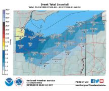
On Monday, snow could begin in the early morning hours which could accumulate a couple of inches of snow. The hard part of the forecast at this time is snow could transition over to a wintry mix (snow/sleet, freezing rain, rain) in the afternoon especially if the warmer air aloft gets this far north (now forecasted to be in the Findlay/Lima area). If it changes to a wintry mix, snow totals will stay somewhat low, but slippery conditions will likely continue. Snow would return in the evening hours as the warmer air moves east. If it doesn’t change to a wintry mix, total accumulations for the storm could be in the 4” range with heavier snow north and west of the Maumee River. Again, it is early and this is preliminary information. EMA will be updating forecast information on its Facebook page through the weekend.
Dangerous recorded setting cold air will start moving into the area Tuesday afternoon. Wednesday will be the coldest day with actual high temperatures struggling to reach 0 degrees F. Overnight wind chill temperatures will be near -40 degrees F. This is very dangerous cold air, so please start preparing this weekend for conditions we have not seen in a long time (at least for a couple of days).
FUN FACT: Today is the 41st anniversary of the Great Blizzard of 1978! At least we are not looking at that situation again!


