The Wood County Emergency Management Agency has issued the following advisory:
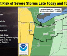
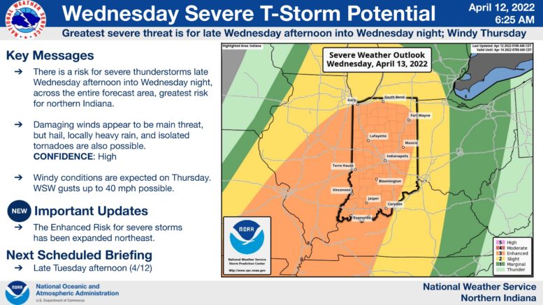
The NWS Storm Prediction Center has upgraded all of Wood County to “Slight Risk” for severe thunderstorms Wednesday. Additionally, NWS has expanded the “Enhanced Risk” from Indiana to the Ohio border increasing our risk for severe weather. It is important to understand that even though the thunderstorm category “slight risk” may not sound substantial, it is still an elevated threat of severe weather. See the NWS severe thunderstorm risk category definitions below for reference:
· Marginal: Isolated severe thunderstorms possible; limited in duration and/or coverage and/or intensity.
· Slight: Scattered severe storms possible; short-lived and/or not widespread; isolated intense storms possible.
· Enhanced: Numerous severe storms possible; more persistent and/or widespread; a few intense.
· Moderate: Widespread severe storms likely; long-lived, widespread, and intense.
· High: Widespread severe storms expected; long-lived, very widespread, and particularly intense.
Wednesday’s weather is expected to come in two rounds. The first round is expected to begin around 10 am with lightning, a potential for small hail, and wind gusts of 35 mph. The second round is expected after midnight (Wednesday into Thursday) with the risk of being more severe. Damaging winds over 60 mph are possible as well as an isolated tornado and quarter sized hail.
Due to the rain and cloud cover during the day Wednesday, it could inhibit the strength of the storms late Wednesday night.