The Wood County Emergency Management Agency has issued the following advisory:
As of 5 p.m. Tuesday:
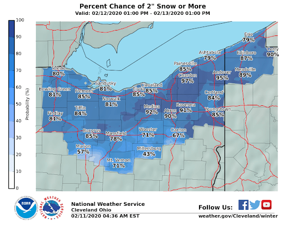
NWS Cleveland has placed Wood County (all of their service area) under a Winter Weather Advisory from 4 p.m. Wednesday until 10 a.m. Thursday Morning.
Snow is expected to begin for Wood County around 2p.m. Current models show approximate snow fall increased to 3.5” to 4” by 7 a.m.. An additional 1” of snow can be expected throughout the day Thursday.
***
As of 8 a.m. Tuesday.
Starting Wednesday afternoon we are going to experience snow, freezing rain, sleet, cold then expect temperatures to increase with a chance of rain. Based on information today (Tuesday, Feb. 11) from National Weather Service Cleveland the scenario is expected to play out as follows:
Wednesday afternoon expect snow to begin 2-4 p.m. continuing into the evening. The snow will increase with a possible mix of snow, sleet and freezing rain during nighttime hours with an approximate 3” accumulation. Snow will continue throughout Thursday with up to 1” of additional snow.
Temperatures will drop Thursday night into Friday morning with a low of 7 degrees F with a wind chill of -4. Friday will remain cold continuing into Saturday when the high will be 34 degrees F. Chance of precipitation is 30% Saturday through Monday with a high temperature Monday of 45 degrees F.
This forecast is based on the center of Wood County. Please monitor the local media for the most current, up-to-date information for your area.
The EMA will continue to monitor weather conditions and provide updates of any change impacting Wood County.