The Wood County Emergency Management Agency has issued the following advisory:
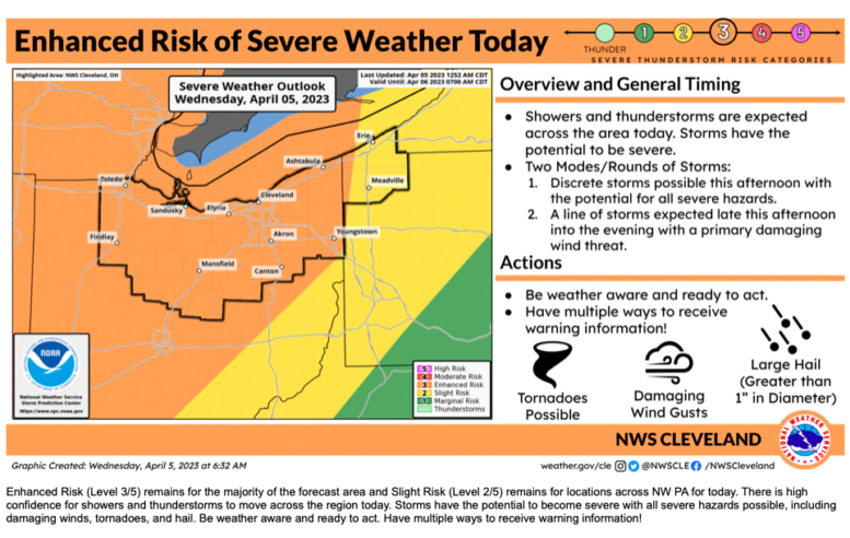
This is our morning briefing from NWS Cleveland for today’s (April 5) weather event. The two changes we should take note for Wood County: the timing is 11 a.m. to 5 p.m. and the area of potential EF2 or greater tornados has expanded. We are no longer just on the eastern edge.
We will continue to monitor and if you can, attend the NWS Facebook update at 11am today.
Take this time to prepare for today’s severe weather: have a shelter, multiple ways to receive emergency notifications, flashlights with extra batteries, charged cell phones and any personal needs. And don’t forget the pets.
If you need to shelter such as in a basement, make sure you have shoes, coats, etc., should there be damage when you come out. We have heard a number of times people come out of their shelter/ safe space to have nails, debris and other sharp objects.
Over the past few days, we have received a number of request for a list of shelters in Wood County. While it seems like an easy project, it is very complicated with many moving parts. The EMA has no control of these shelters, cannot guarantee they will be open, structurally sound, in the process of being remodeled, in use by the owner, safe and secure. Sending someone to inaccessible or unsafe location is not in the public’s best interest.
We will continue to monitor and provide update as appropriate.
What has changed:
· No significant changes to the outlook and event potential at this time.
· Showers and thunderstorms have developed over the Middle Mississippi River Valley this morning. These will move northeast into the area today with additional storm development expected by early afternoon.
What to expect:
· There is high confidence for showers and thunderstorms to move across the region today. Storms have the potential to become severe with all severe hazards possible, including damaging winds, tornadoes, and hail.
· Confidence is low-to-medium on early, discrete storms that may produce significant severe hazards, including tornadoes, large hail, and damaging winds.
· Confidence is medium-to-high for a final line of thunderstorms from late afternoon through the evening with the main hazard of damaging wind gusts.
· There still is some uncertainty in the forecast. Cloud cover is present across the region this morning and will continue through the day. Clouds could make additional early storm development more difficult and there could be less storm coverage. The other uncertainty factor is that once storms start, there is potential for storms to congeal and interact with each other, favoring a damaging wind or weak tornado threat, instead of a significant severe episode.
· Non-thunderstorm wind gusts will be strong once again today with southerly wind gusts in excess of 35 mph possible during the late morning and afternoon hours.
There will be a Facebook Live at 11 AM on the NWS Cleveland Facebook Page.
Another formal email briefing will only be issued as needed.
The following links can be bookmarked for the latest information:
Updates from the Storm Prediction Center can be found at www.spc.noaa.gov/
As storms develop, Local Storm Reports can be found here.