Brad Gilbert, Emergency Management Agency director for Wood County, has issued the following advisory:
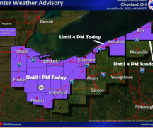
A strong storm system moving into the lower Great Lakes late tonight and Tuesday will bring windy conditions overnight and into the day on Tuesday. The latest forecast models indicate a little better news than what we expected a few days ago. Although a thunderstorm cannot be ruled out especially overnight tonight, the widespread severe weather threat will stay well south and southeast of NW Ohio. Rain (with some isolated thunderstorms) will move into the area late tonight and it could be heavy at times overnight, but there are indications that the steady rain will move east of the area by the mid-morning hours with just widely scattered showers possible into the mid-afternoon. Winds will increase and be sustained at 20-30 mph with gusts as high as 40 mph. Winds should subside slowly (but still breezy) towards Tuesday evening and Tuesday night.
Get ready for some winter-like temperatures this upcoming weekend. Time to bring in the garden hoses and those type of things that are susceptible to freezing!