Brad Gilbert, Emergency Management Agency director for Wood County, has issued the following advisory:
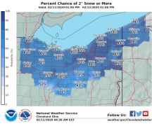
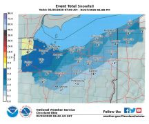
A strong storm system with a lot of moisture will be moving across the eastern part of the country late tonight and on Wednesday. Fortunately, NW Ohio will be in an area of the storm that will have a smaller impact (compared to other areas) from this storm. With that said, we are still looking at some winter weather Wednesday morning that will cause slippery conditions. Light snow will move into the Wood County area (southwesterly end first) around daybreak Wednesday morning. Total snow accumulations should only be around 1”. There will be a period of time in the mid to late morning hours that snow will change over to a mixture of sleet and very light freezing rain before turning to all rain in the afternoon. Again, not a huge winter storm for this area, but enough to cause some morning commute issues and another tough decision process for the local schools.
At this hour, the NWS is reviewing criterial for a possible Winter Weather Advisory (which is already posted in the counties to our west and south), but forecasters are unsure at this time if conditions will be bad enough to warrant an Advisory or not. They will make a final decision this afternoon. Slowly warming temperatures this week and into the weekend will bring rain along with a chance of thunderstorms on the weekend.