The Wood County Emergency Management Agency has issued the following advisory:
Wood County is under an increased risk of severe weather for the next 48-hours.
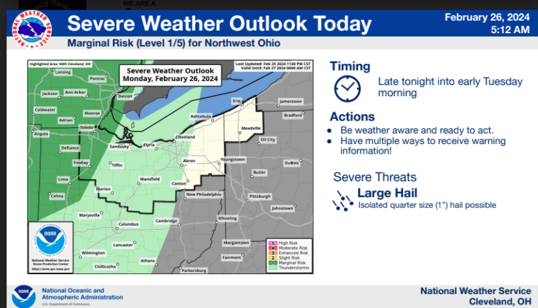
Monday Evening- Tuesday Morning- Marginal Risk (1 of 5)
Rain may start before midnight, with the storms occurring most likely between 3-6am Tuesday. The main threat will be hail; isolated quarter size (1”) is possible.
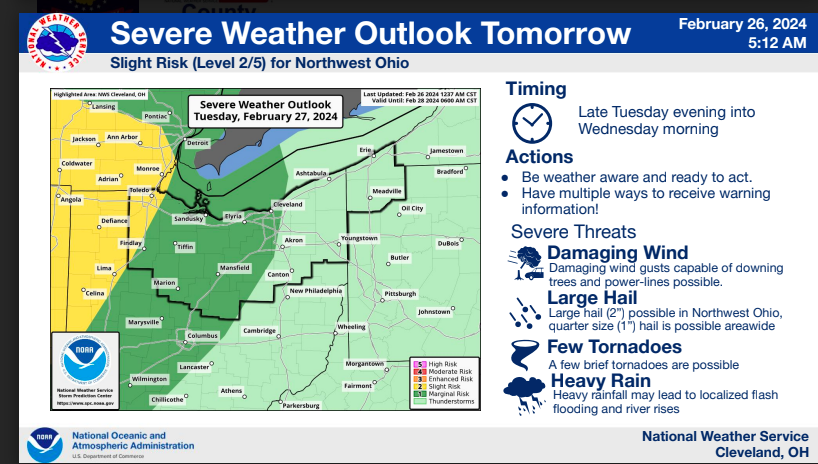
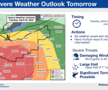
Tuesday Evening- Wednesday Morning Slight Risk (2 of 5)
Tuesday during the day is expected to be cloudy, but with warmer than normal temperatures into the upper 60s in the afternoon. Showers and thunderstorms will become likely Tuesday night into Wednesday morning ahead of a strong cold front. Some of these storms may contain marginally severe wind gusts and isolated large hail (2”). Brief heavy downpours and numerous lightning strikes may also be associated with these storms.
This storm has the greatest potential, while low to have brief isolated tornadoes. Due to the timing of these storms during the nighttime hours, it is important to make sure you have multiple ways to get emergency alerts. We encourage everyone to have multiple ways to receive alerts such as NOAA Weather Radio, cell phone apps, Wood County Mass Notification System CodeRED (if you have not registered the link is https://public.coderedweb.com/CNE/en-US/BFAB7B074BCD ) and these devices are at sufficient volume to wake you up.
Other considerations:
- Have flashlights with good batteries near your bed.
- Know where your safe space is.
- Prepare your safe space if needed.
- Multiple weather phone apps.
- Make sure location services is turned on your phone.
- Keep your cell phone charged.
- Multiple technologies to receive alerts.
- Proper clothing in case you need to go to your safe place quickly.
- Do not forget about your pets.
- Secure loose outdoor items.