Jeff Klein, Emergency Management Agency director for Wood County, has issued the following advisory:
The quick highlights of this afternoon’s briefing:
The rain tonight will be changing over to snow starting about 7am in the north part of the county working southward.
Wednesday snow fall expected to be 8-12”, heavy wet snow. Minor damage to trees and power lines possible.
Thursday snow fall 6-8”, light and fluffy which will increase the chance of snow drifts.
Friday strong wind gusts causing snow drifts making it hard to keep the roads clear.
90% confidence 10” snow or more, 10% chance of 17.9” snow.
From this morning:
The approaching storm continues to have a major impact for Wood County. The EMA continues to urge everyone to prepare before it begins.
It does appear in the northern part of Wood County will be seeing snow around the 7 a.m. Wednesday time frame. However, the southern portion of Wood County could be closer or even after noon.
If you have plans, appointments, etc., if possible, we suggest you consider canceling and rescheduling them until there’s better weather.
What to expect:
- Rain will change to mixed wintry precipitation and eventually to all snow from NW to SE Wednesday through early Thursday evening
- Widespread snow should then end from west to east Thursday night through Friday afternoon
- The greatest snow totals are still expected in northwest OH and along/near Lake Erie in north-central/northeast Ohio and northwest Pennsylvania
- The best chance for a longer duration snow/sleet/freezing rain mix continues to exist south of US-30
- The greatest uncertainty continues to involve the spatial extent of mixed wintry precip, especially freezing rain, and how much ice will accumulate from freezing rain
- Blowing and drifting snow and reduced visibility are expected at times, especially in northwest Ohio and along/near Lake Erie in north-central/northeast Ohio and northwest Pennsylvania
- Regardless of the exact snow, sleet, and ice totals, major impacts to travel are expected Wednesday night through Friday morning
What has changed:
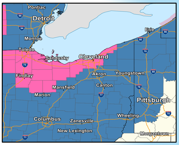
- The Winter Storm Watch was upgraded to a Winter Storm Warning (pink counties in below image) for portions of northern Ohio, including the Toledo and Cleveland metro areas, and takes effect at 7 a.m. or 7 p.m. Wednesday
- A Winter Storm Watch (blue counties in below image) remains in effect for the rest of northern OH and northwest PA due to continued uncertainty regarding precip types and amounts, and takes effect at 7 p.m. Wednesday
- All watches and warnings are in effect until 7 a.m. EST Friday, February 4
- The projected storm track has shifted southeastward slightly, which now favors more snow and sleet, and less freezing rain for northern OH and northwest PA
- Our latest snowfall and ice accumulation forecasts are available at weather.gov/cle/winter