By JAN LARSON McLAUGHLIN
BG Independent News
Before investing in bike lanes and sharrows, Bowling Green City Council asked for input from the people who most often don their helmets and pedal to work, school or play.
On Monday evening, the Bicycle Safety Commission presented to City Council’s Transportation and Safety Committee the best ways to connect destinations in the city by installing sharrows and bike lanes.
And City Council member Greg Robinette repeated his commitment to create a bike/walk path to the community center on Newton Road.
Based on a ranking system looking at the frequency of bicycling on the streets, the potential for adjacent bicycling destinations, and the connection to current or future bicycling routes, the commission made the following suggestions.
Recommendations for north-south streets for sharrows:
- Wintergarden (Poe to Sand Ridge)
- Maple (Conneaut to Sand Ridge)
- Fairview (north of Poe) [Note: south of Poe already has sharrows]
- Grove (Poe to Sand Ridge)
- Church (Clay to Sand Ridge) and Kenwood (Sand Ridge to Napoleon)
- Prospect (Poe to E. Napoleon) and/or N. & S. Enterprise (Poe to Lehman
- Thurstin (Poe to E. Wooster) and Manville (E. Wooster to E. Napoleon)
- North College (south of Poe Road) and South College (Main to Napoleon)
- Troup Street (from Scott Hamilton to East Wooster) [only 2 blocks]
Recommendations for east west streets for sharrows:
- Newton (from Community Center to North College)
- Frazee (from Fairview to North College)
- East Merry (Thurstin to Mercer)
- Clay and Ridge (Main to Mercer)
- West Wooster (Wintergarden to Haskins)
- Clough (Main to Mercer) [need to consider dangerous curve around windmill]
- Pearl (Wintergarden to Main)
- Napoleon (Kenwood to South College only)
Recommendations for priority streets for bike lanes:
- Haskins Road (Community Center to West Wooster)
- Brim Road (Newton to West Poe)
- Main Street (from Newton to Gypsy Lane)
- Wooster (from Wintergarten/Haskins to Mercer and join with new East Wooster pedestrian-bike path)
- Poe Road (Mitchell to North Dunbridge)
- Napoleon Road (South College to South Dunbridge)
- Gypsy Lane Road (Sand Ridge to Klotz Road. and/or South Dunbridge)
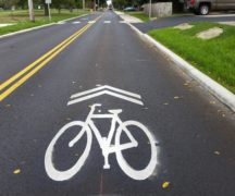
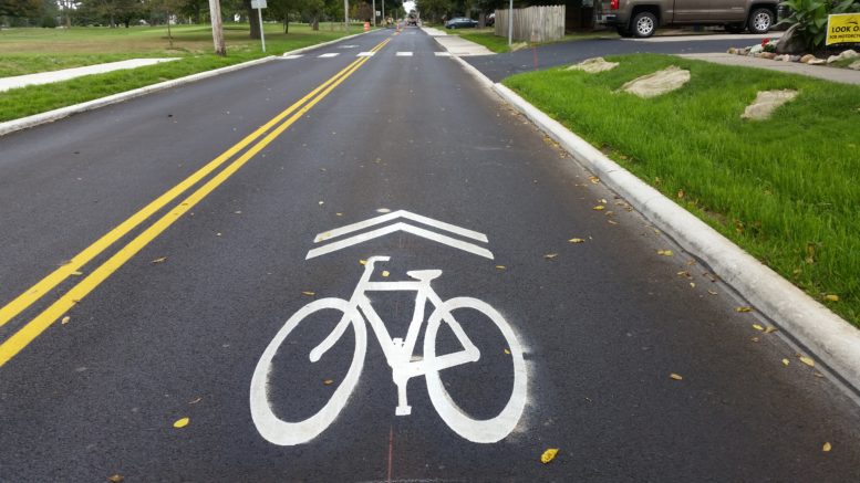
Steve Langendorfer, chairman of the Bicycle Safety Commission, talked about the differences between sharrows which are painted bicycle shapes on the pavement and actual bike lanes.
“Sharrows reinforce that bicycles are vehicles that have all the same rights and responsibilities,” Langendorfer said.
Sharrows are also much less expensive.
“It would be prohibitively expensive” for Bowling Green to install many bike lanes, he said. Plus the lanes would eat up many tree lawns and require work to underground utilities.
However, sharrows don’t segregate cars and bikes, so they aren’t as safe for cyclists.
“The big ship wins,” leaving the bicyclists on the losing side of battles with cars, he said.
City Council’s Transportation and Safety Committee – made up of John Zanfardino, Mark Hollenbaugh and Greg Robinette – realizes the list of bike priorities could take up to 20 years to achieve. The bike commission members understand.
“We recognize these won’t be done all at once,” Langendorfer said. “We just need to plug away at a few streets a year.”
The council committee thanked the Bicycle Safety Commission for its work ranking the streets and setting priorities.
“They are the ones riding around out there all the time,” Hollenbaugh said.
The committee talked about which streets should be prioritized.
“The biggest challenge we have is what we want to push forward,” Zanfardino said. “We can’t do it all. We know that.”
Hollenbaugh suggested that the entire list of recommendations be passed on to Public Works Director Brian Craft, since the timing of street paving will play a role in the addition of sharrows or bike lanes. Robinette and Zanfardino agreed that the entire list should be given to Craft, along with a suggestion that he focus on the top 10 streets, and on the streets on the list that will soon be paved.
“The point is, we’re getting started,” Robinette said.
Zanfardino acknowledged that sharrows are not universally embraced by all bicyclists, but they are more fiscally responsible for communities.
“I can say I personally believe in sharrows,” Zanfardino said. “I feel like it really makes it easier to ride across our town.”
While sharrows are not safer than separate lanes for cyclists, Langendorfer said that he has noticed an educational component playing out since Bowling Green put sharrows on Conneaut and Fairview avenues a couple years ago.
“More cars give bicyclists greater leeway” than the required three feet, he said. “Cars give me a lot more space.”
“If you build the sharrows, they will bike,” Langendorfer said.
Following are the pros and cons of both types of biking infrastructure:
Sharrow Pros
- Reinforces bicycles equal vehicles
- Bicycles/autos share space
- Most suitable for lower speed streets, and motorists respond
- Similar experience to all roads
- Most fiscally reasonable
Sharrow Cons
- Requires defensive biking
- Requires cyclists obey laws
- Law of gross tonnage applies
Bike Lane Pros
- Bicycles segregated from autos safer than shared streets
- Most necessary for high volume, higher speed streets
Bike Lane Cons
- Require wider streets
- Most expensive infrastructure option (unrealistic for BG)
- Only as safe as driver/cyclist compliance
- Cause confusion for drivers
Langendorfer talked about some routes in the city that make even experienced bicyclists nervous.
“My heart rate goes up about 50 beats,” when he traverses the curve around the windmill on Clough Street.
And “if you want a life-threatening experience,” try riding East Poe Road over the Interstate 75 overpass, he said.
Council President Mike Aspacher thanked the Bicycle Safety Commission for its work on the infrastructure recommendations.
“I feel like we are doing everything we can do to encourage people to bike more. You have set the stage for bike infrastructure,” Aspacher said.
As for the proposed path to the community center, Robinette said no exact route had been decided, but that it would link the campus of Bowling Green Middle School and High School to the center. Grants are being sought to help with the expense.
“I promise to continue being a champion for this,” Robinette said. “I think it’s important.”
The Bicycle Safety Commission created a bike-ability map of the city about two years ago. The map rates routes on the following factors related to street safety:
- Traffic speed limit on street
- Street width
- Traffic volume
- Presence of on-street parking (a.k.a. door zone)
- Location of underground/above ground utilities
- Number of intersections without red (stop signs or stop lights)
Rideability Map – 2017
Current BG bicycle route map