The Wood County Emergency Management Agency has issued the following advisory:
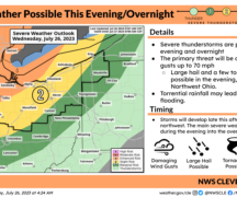
Severe thunderstorms, high winds, hail, and an isolated tornado are possible late this evening and overnight. NWS indicates that conditions are favorable for damaging to destructive straight line winds in excess of 60-70mph. If the storms do track across northwest Ohio, the current predicted timing appears to be late evening/overnight 10 p.m. to 2 a.m. According to National Weather Service, there is some uncertainty on where the strongest corridor of winds will reside, but the current environment is supportive of damaging wind gusts (75mph+).
The majority of northwest Ohio (including Wood County) is under an “Enhanced” risk for severe weather. Please note that the scale for rating begins at
0-TSTM (general or non-severe thunderstorms), 1-marginal, 2-slight, 3-enhanced, 4- moderate, 5-high. We are currently in the 3- Enhanced with some discussions of being upgraded to 4-moderate if trends continue. Enhanced means that numerous severe storms are possible. They may be persistent, widespread, and a few intense. Repeated thunderstorms and heavy rainfall could also lead to flash flooding.
As soon as possible, consider moving loose outdoor items indoors or tying them down. Decide on where you would relocate if needed (basement, lower-level, away from windows). Locate and test flashlights in the event of a power outage. Make sure you have multiple ways to get warnings (CodeRED, weather apps, NOAA radio). Charge your devices and make sure they are not on do not disturb/silent mode overnight. The timing of these storms may hit while you are sleeping.
As if that wasn’t enough, Wood County is also under an excessive heat watch from Tuesday afternoon- Wednesday evening. We figured we would ensure you knew about this, but to focus on the severe storms for now. We will continue to provide you with updates as available.