The Wood County Emergency Management Agency has issued the following advisory:
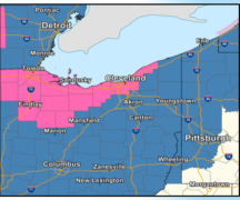
The National Weather Service Storm Prediction Center (SPC) has Wood County is under a “moderate risk” for severe weather. To put this in perspective, it has been several years since we have been under this high of a potential for severe weather. The SPC is very conservative in issuing a “Moderate Risk” and are confident on the severity of the up-coming weather.
The timing for the severe weather: storms will enter the area mid-afternoon around 3 pm with the focus of concern between 4 and 7 p.m. As of now the this will be straight line winds up to 70mph. While this type of storm is not conducive for large scale tornados; however, a tornado threat (smaller EF0-EF2) is still possible due to storm rotation.
While we monitor multiple sources to get accurate information, all sources indicate severe weather for Wood County. Our confidence is high we will experience some form of severe weather. A Severe Thunderstorm WATCH has been issues for areas west of Wood County and we anticipate the SPC expanding the watch area to include Wood County within the next 2 hours.
Recommendations
- Have a plan what to do should severe weather occur
- Limit travel this afternoon and evening.
- Secure all loose outdoor items
- Monitor local media and download weather apps
- Make sure your location services in on
- Register for Wood County’s CodeRED Mass Notification System
- Keep cell phones charged and flashlights ready
- Prepare for power outages and utility disruptions
- Prepare for downed trees and blocked roadways
The EMA will continue to monitor conditions and provides update as they are available.
Special thanks to Brad Gilbert for assisting with this update.