Erin Konecki, Emergency Management Agency deputy director for Wood County, has issued the following advisory:
Below is the latest from NWS Cleveland.
At this time, our rivers are currently in the No flooding stage and are forecasted in the minor flooding range. If you do witness any ice jams/dams in your local area, feel free to share that information with us and we will get it to National Weather Service.
This information helps them predict associated flooding that can occur with both their build and release. NWS Northern Indiana reported in their briefing that the Maumee River does have what they determined to be heavy ice present. We are in contact with local responders to keep an eye on the areas of common impact (Grand Rapids and Pemberville).
Again, if you are seeing any issues in your area please let us know. We were able to visualize the Portage from Woodville to Pemberville and the Maumee River from the Damascus Bridge to Waterville today in person and the conditions are extremely variable depending on location.
There is also already considerable snowmelt coming across roadways in certain areas off of the fields. Please be vigilant as more rain approaches and freezing temperatures occur. The road conditions across the county may get very tricky to navigate.
See below for the highlights provided to us from NWS Cleveland.
What’s Changed:
Several River Flood Warnings have been issued, many of which are expected to reach moderate and possibly major flood stage. See latest Flood Warning statements here: https://forecast.weather.gov/product.php?site=cle&issuedby=CLE&product=FLW
A Winter Weather Advisory has been issued for mixed precipitation.
Wind Advisory was extended to 5 AM Friday.
What to expect:
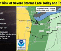
A slow-moving cold front will approach the area Wednesday and move across the region Thursday.
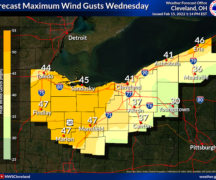
Southerly winds 20 to 30 mph with gusts to 45 mph are expected generally along and west of I-71 and along the Lake Erie shoreline this afternoon through tonight.
Heavy rain combined with snowmelt and potential ice jams will produce a threat for flooding for most of the area Thursday.
A wintry mix is expected for northern Ohio Thursday afternoon through Thursday night. A Winter Weather Advisory has been issued for this reason.
The following links can be bookmarked for the latest information:
· NWS Cleveland River Observations and Forecasts (AHPS)
· NWS Cleveland Hazardous Weather Outlook Text Product (HWO)
· NWS Cleveland Website for current watches and warnings
· NWS Cleveland Quick Brief Webpage, which includes the latest briefing slides
· Information on the strong winds can be found here.