By JAN LARSON McLAUGHLIN
BG Independent News
The Wood County Park District signed onto an effort last week to join a plan to connect the nation with a network of bike routes.
“It’s a great effort” and great for tourism, said Neil Munger, director of the park district.
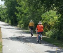
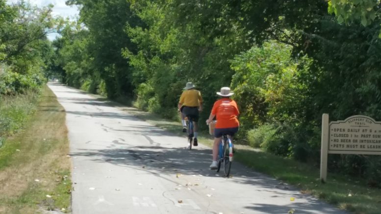
The park district’s Slippery Elm Trail would be part of the network.
“It makes a whole lot of sense if you look at it regionally,” Munger said.
The network of bike routes would stretch across the nation. The north-south route, as planned, would travel through Bowling Green.
“It is something still in the planning stages, but no concrete plans yet,” he said.
The Ohio Department of Transportation wants to designate a signed network of U.S. and state bicycle routes that will accommodate long distance cycling and also serve as local connections. The proposed routes follow the American Association of State Highway and Transportation Officials’ national initiative. More than 11,000 miles have been designated across 23 states.
The plan is quite ambitious – considering regional efforts to connect northern Ohio with bike routes have hit some roadblocks. Munger explained that a trail, which stretches from Woodville almost to Cleveland, and Maumee almost to Indiana, hit a snag in the middle.
“The hole in the middle is the Wood County portion” and some of Ottawa County, he said. Efforts to find and designate a trail between Millbury and Maumee have been unsuccessful.
Another missing link in Wood County occurs in the Chessie Circle Trail, which was initially planned to have a river crossing into Lucas County on the bridge next to the turnpike. However, that proved too costly.
“We keep looking at different routes,” Munger said.
Following is information on the possible routes for the national bike network.
US Bike Route 25 (north to south) starts in Mobile, Alabama, and ends in Sault St. Marie, Michigan. It parallels Interstate 75 along much of the Ohio route.
The possible Wood County portion would cross over the Perrysburg-Maumee bridge, then follow the sidepath south along West Boundary Street to the sidepath on the north side of Indiana Avenue. Then head west following the sidepath along Indiana Avenue to River Road. Then on River Road, it would continue west to Hull Prairie Road into Perrysburg Township. Then go south on Hull Prairie Road into Middleton Township to Hannah Road. Then along Hannah Road in Plain Township to Brim Road. Then south on Brim Road into the City of Bowling Green to Newton Road. Then east on Newton Road to Fairview Avenue. Then south on Fairview Avenue to Conneaut Avenue where there is a jog to the west to Maple Street. Then south on Maple Street to Sand Ridge Road where there is a jog to the west to the Slippery Elm Trail. Then following the Slippery Elm Trail south to Broadway Street in the village of North Baltimore. Then west on Broadway to Main Street. Then south on Main to Ohio 18 in Henry Township. Then west on Route 18 to Mitchell Road. Then south on Mitchell Road to Belmore Road. Then west on Belmore Road to Liberty Hi Road then south on Liberty Hi Road into Hancock County.
US Bike Route 30 (west to east) connects Montana to Massachusetts. More locally it links Detroit, Toledo, and Cleveland. Much of this route in North Central Ohio is along the North Coast Inland Trail.
The Wood County portion heads south on Drouillard Road crossing into Wood County and the city of Northwood and south into the village of Walbridge where Drouillard becomes Main Street. Continuing south to Ayers Road in Lake Township. Then east on Ayers Road to Bradner Road at the edge of the village of Milbury. Then south on Bradner to Latcha Road. Then east on Latcha Road to Fostoria Road. Then north on Fostoria Road into Ottawa County.
US Bike Route 40A (west to east) begins in New York City and ends in Wyoming. The more northerly alternative in Northwest Ohio makes use of the Wabash-Cannonball Trail, goes through Waterville, then follows a route across northern Wood County before joining onto the North Coast Inland Trail near Genoa.
The route would cross into Wood County at the Waterville bridge, entering Middleton Township. Then north on Ohio 65 to Five Point Road. Then east on Five Point Road in Perrysburg Township to Stony Ridge Road in Troy Township. Then north on Stony Ridge Road to U.S. 20/23. Then jog southeast on Route 20/23 to East Broadway Street. Then north on East Broadway Street to Genoa Road, adjacent to Lake Township. Then east on Genoa Road into Ottawa County. It joins USBR 30 on the North Coast Inland Trail near the Village of Genoa.