The Wood County Emergency Management Agency has issued the following advisory:
The latest of the chance of severe weather tonight.
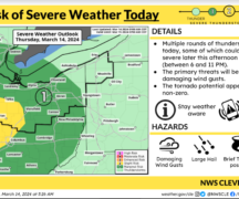
· Southern Wood County continues to remain in an “Enhanced” risk (3 of5) and greater than 10% chance of an EF2 –EF5 tornadoes.
· Northern Wood County continues to remain in a “Slight” risk (2 of 5) and 5-9% chance of tornadoes.
· All of Wood County is under a significant chance of 1”-2” sized hail or larger.
· The last model provided to us, has rain starting near 6pm and the severe weather at I75 at 7 p.m.
· The trend for the main round of thunderstorms, and associated severe weather threat, is looking to be slightly later. The showers and embedded thunderstorms currently moving into western Ohio arenot the main event and are not expected to produce severe weather. This activity is expected to fade as it moves farther east into drier, more stable air by mid to late afternoon. Extensive cloud cover associated with this first wave of showers and thunderstorms is already showing breaks over Indiana, where heating of an increasing moist low-level air mass is occurring.
· New thunderstorms are expected to develop in this more unstable air mass this afternoon and will move into NW Ohio this evening, giving northern Ohio time to sufficiently recover from the afternoon showers/storms. Timing now looks like the storms could reach a Toledo to Findlay line by 7 p.m., but could be as early as 6 p.m. In terms of the severe weather threats, we have increasing confidence in a couple of tornadoes in NW Ohio, roughly from a Toledo to Marion line. This area is also most at risk for large hail up to 1 to 2 inches in diameter, as well as damaging winds up to 70 mph.